
Last Updated on 30.3.2026 by Lukas Vondracek
Banff National Park offers plenty of different hikes to choose from, depending on distance, views, or difficulty. The easiest hikes in Banff are usually very short trails that connect a parking area with a viewpoint. In many cases, you don’t have to deal with much elevation gain or difficult terrain.
Some of these easy hikes can even be found directly in the towns of Banff or Lake Louise and are accessible by bus or on foot from your accommodation. Others require a short drive or public transportation – some of these transport options are described in the article Canadian Rockies without a Car.
In this article, we will focus only on short and easy hikes. Each trail includes basic information about distance, difficulty, access to the trailhead, and the best season to visit.
This list is perfect for beginners, families with kids, or anyone who wants to enjoy beautiful views without a long or challenging hike.

Best Easy Hikes in Banff (Quick List)
If you are short on time, these are some of the easiest and most beautiful hikes in Banff National Park:
- Moraine Lake Rockpile
- Peyto Lake Viewpoint
- Bow Falls Trail
- Lake Louise Lakeshore
- Stewart Canyon Bridge
Map of Easy Hikes in Banff
I created a map with several easy hikes in Banff National Park and divided them into three groups using colors.
Green – hikes located directly in the town of Banff
Yellow – hikes accessible by bus
Blue – hikes that require a car or a guided tour company
Easy Hikes in Banff National Park
In this section I describe individual hikes, including their distance, difficulty, and accessibility. This is not a complete list of every trail in the area, but it includes some of the most accessible and enjoyable options. Distances listed below are for the full loop or the round-trip hike.
Easy Hikes in Banff and Nearby
Many hikes in and around Banff are easy to reach on foot, by bike, by tourist bus, or by public transportation. Some locations require taking a gondola to reach the starting point of the hike.
Bow Falls Viewpoint
You can reach this viewpoint either on foot or by car. There is a parking lot right next to the viewpoint with free parking for up to 3 hours. If you decide to walk, I recommend starting near Bow River Bridge and following the river path.
• Distance: 2.2 km
• Elevation gain: 30 m
• Access: walking from Downtown Banff
• Difficulty: very easy – almost no elevation gain

Tunnel Mountain
This hike has two possible starting points. One is on Saint Julien Road, and the other slightly higher on Tunnel Mountain Drive (where parking is more limited). The trail leads to a viewpoint overlooking the town of Banff and the valley toward Lake Louise. Along the way you will also get views in the opposite direction toward the Bow River and Mount Rundle.
• Distance: 4.4 km (shorter option 3.4 km)
• Elevation gain: 266 m (shorter option 204 m)
• Access: walking from Downtown Banff or by car
• Difficulty: challenging because of the elevation gain – the trail climbs steadily uphill on a forest path. Not suitable for strollers.

Stewart Canyon Bridge
This short walk along the shore of Lake Minnewanka leads to a bridge over the Cascade River, where you can enjoy a nice view into the canyon carved by the river. On hot summer days the bridge is also a great place to cool down thanks to the cold air flowing from the canyon.
If you decide to continue further along the trail, you should travel in a group of at least four people because of wildlife activity in the area.
• Distance: 3.4 km (parking lot to the bridge and back)
• Elevation gain: 20 m
• Access: car or bus
• Difficulty: very easy – paved path and forest trail

Johnston Canyon
This trail follows the canyon along the river using wooden walkways and small bridges built into the rock walls. Most visitors hike to the viewpoints of the two waterfalls, but more experienced hikers can continue further to Ink Pots.
The trail is accessible year-round, but during winter months I recommend bringing ice spikes because the trail can become very icy.
• Distance: 5.2 km to Upper Falls (11.2 km to Ink Pots)
• Elevation gain: 136 m (306 m to Ink Pots)
• Access: car or bus
• Difficulty: relatively easy. The trail gradually climbs uphill and is well maintained, with railings in some sections.


Sulphur Mountain
This trail is usually considered moderately difficult if you hike all the way from the parking lot. However, here we are only talking about the upper section, which you can reach by gondola.
During the summer season it’s best to buy gondola tickets online in advance. At the top you will find a wooden boardwalk that leads to the summit viewpoint. From there you get incredible views of the surrounding valleys and the town of Banff below.
• Distance: 1.2 km
• Elevation gain: 35 m
• Access: gondola – the gondola base can be reached by car or bus
• Difficulty: easy walk along a wooden boardwalk with a few stairs.

Sunshine Meadows
In my opinion, this is one of the most beautiful hikes near Banff. The only downside is that if you don’t want to hike a long and steep hill to get there, you will need to take the gondola. However, it is definitely money well spent. The views from the top are absolutely incredible.
There are several hiking options in this area, but here I will mention only a shorter and a longer loop that belong among the easiest trails. Both routes eventually lead back to the lower gondola station.
• Distance: 7.5 km longer loop (3.1 km shorter loop)
• Elevation gain: 110 m longer loop (17 m shorter loop)
• Access: gondola or hiking
• Difficulty: easy – mostly downhill. The shorter option is almost entirely downhill.

Easy Hikes in Lake Louise and Nearby
Lake Louise is a small village in the Canadian Rockies and one of the most visited places in the region. During the summer season you should expect full parking lots and large crowds. The reason is simple — this area is home to two of the most famous lakes in the Canadian Rockies: Lake Louise and Moraine Lake.
Boom Lake
Boom Lake is a beautiful turquoise glacial lake surrounded by mountains on all sides. The trail to the lake leads almost entirely through the forest. The hike is accessible in all seasons, but during winter or after heavy snowfall I recommend using snowshoes.
• Distance: 10.3 km
• Elevation gain: 220 m
• Access: car
• Difficulty: moderate because of the distance. The trail is mostly flat or gently uphill and follows a forest path all the way to the lake viewpoint.

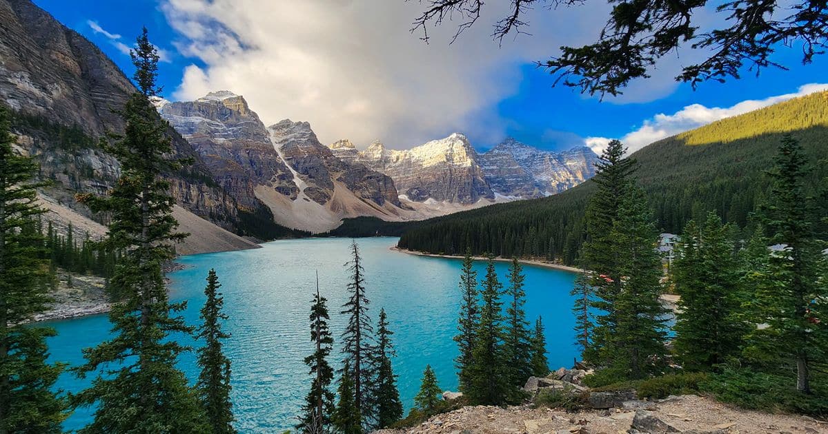
Moraine Lake Rockpile
This is one of the most famous viewpoints in Banff National Park. You can no longer drive directly to Moraine Lake by car. The area is accessible only by shuttle bus, bicycle, on foot, or by cross-country skis in winter (Check out the Avalanche forecast. When you want to reach the lake on xc skies you have to pass an avalanche area).
The Rockpile viewpoint offers the classic and most photographed view of Moraine Lake. For more details, see the article How to Get to Moraine Lake Without a Car.
• Distance: 700 m
• Elevation gain: 10 m
• Access: shuttle bus, bike, smaller transport companies
• Difficulty: very easy – a short walk up a small pile of rocks.
Lake Louise Lakeshore
This is an easy walk along the shore of Lake Louise. If you walk all the way around the lake, you will also get a beautiful view of the famous Fairmont Chateau Lake Louise hotel.
This location is one of the most visited places in Banff National Park. If you arrive by car, expect expensive parking. Another option is to reserve a shuttle bus in advance.
• Distance: 4.6 km
• Elevation gain: none
• Access: car or bus
• Difficulty: very easy walk along the lakeshore.

Easy Hikes Along Icefields Parkway
Icefields Parkway is often described as one of the most beautiful drives in the world — and I completely agree. The road is surrounded by massive mountains and glaciers. Along the way you will find turquoise lakes, glacial waterfalls, and many easy hiking trails.
Bow Glacier Falls
This trail follows the shore of Bow Lake and leads to a waterfall flowing from the Bow Glacier. The hike is not particularly difficult. You can park either in the parking lot along the highway or in a smaller parking area directly next to the lake.
• Distance: 8.8 km
• Elevation gain: 135 m
• Access: car
• Difficulty: moderate – beautiful trail along the lake with a rocky section near the waterfall.
After a rockfall accident in 2025, the final part of the trail is currently closed. However, you can still walk to the end of the lake.

Peyto Lake Viewpoint
The trail to the Peyto Lake viewpoint is a very short walk. From the parking lot you follow a paved path straight to a wooden viewing platform with an incredible view of the famous turquoise Peyto Lake.
• Distance: 1.2 km
• Elevation gain: 35 m
• Access: car or guided tour buses
• Difficulty: very short and easy walk.

Mistaya Canyon
If you want to see the incredible power of water, make sure to stop at Mistaya Canyon. It is a short walk from a small parking lot right next to the highway.
The canyon has been carved into the rock by strong currents from melting snow and glaciers in the surrounding mountains along the Icefields Parkway.
• Distance: 1.2 km
• Elevation gain: 40 m
• Access: car
• Difficulty: easy walk along a forest trail.

Which Easy Hikes i Banff Have the Best Lake Views?
• Lake Louise Lakeshore
• Moraine Lake Rockpile
• Bow Lake
• Peyto Lake Viewpoint
• Lake Minnewanka – Stewart Canyon Bridge
When Is the Best Time for Hiking?
The best time for hiking in Banff National Park is during the summer season, from mid-June to the end of September. During this time all trails are usually accessible, but you should expect large crowds, especially at the most popular places in the park.
This is also the period when most trails are free of snow. However, it’s still possible to encounter temporary restrictions from Parks Canada or trail closures due to wildlife activity or trail maintenance.
In autumn, many visitors come mainly for photos during the Larch season, when the larch trees turn bright yellow after the first colder nights. This usually happens from late September to early October, depending on the weather.
Many hikes mentioned in this article can be done year-round, but in winter or after heavy snowfall I recommend using snowshoes on some trails. During the winter season it is also important to check avalanche conditions on the Avalanche Canada website if you plan to travel near avalanche terrain.

Tips Before Visiting the Trails
Before visiting Banff National Park, it’s good to know that some hikes require advance reservations for shuttle buses or gondolas. Parking can also be difficult in some areas, and there are a few important things you should never forget to bring.
Parking
During the summer season, parking becomes one of the biggest challenges in the park. Parking lots often fill up early in the morning, especially at Lake Louise Lakeshore, where parking fees are also quite high.
If you want to find a parking spot, it’s best to leave your accommodation early in the morning. You can find more information and current prices in the article Parking in Banff and Lake Louise 2026.
Park Pass
To enter Banff National Park, you need a valid Parks Canada Park Pass. You can buy it online, at visitor centers, or at the park entrance kiosks.
A park pass is required even if you travel by bus. You can find more information in the article Parks Canada Pass.
Gondolas
If you plan to visit Sulphur Mountain or Sunshine Meadows, be prepared to pay for a gondola ride (unless you want to hike a long and steep trail to reach the top).
You can find gondola prices on the Banff Gondola website. I recommend buying tickets in advance, especially during summer. For Sunshine Meadows, tickets can be purchased online or directly at the station.
Public Transport and Shuttle
Many trails around Banff and Lake Louise are accessible by public buses or shuttle services operated by private companies that offer transportation and guided tours.
You can find some useful transportation options in the article Canadian Rockies without a Car.
Equipment
Most hikes take place in nature outside of towns, which means you may encounter wildlife, especially bears. In most situations bears avoid people, but there is always a chance you could surprise one on the trail. Because of this, it is highly recommended to carry bear spray.
Mobile phone signal is very limited in the mountains, so it’s a good idea to bring a device that can communicate via GPS. I personally use Garmin InReach, which provides weather forecasts, SMS communication, and includes an SOS button that can call for help in case of an emergency.


Summary
Banff National Park offers many beautiful trails that are not difficult at all. Even during a short walk you can see turquoise glacial lakes, waterfalls, and incredible views of the Canadian Rockies.
If you don’t have a full day for long mountain hikes, these easy hikes in Banff allow you to experience some of the most beautiful places in the park without long distances or steep climbs. All you need to do is choose a trail based on location and enjoy the amazing nature of this national park.
Are you wondering what to pack for your trip? Find it in an article What to Pack for the Canadian Rockies
FAQ
What is the easiest hike in Banff National Park?
Some of the easiest hikes in Banff include Moraine Lake Rockpile, Peyto Lake Viewpoint, and Bow Falls Trail. These are very short trails with minimal elevation gain.
Are these hikes suitable for beginners?
Yes, most of the trails on this list are perfect for beginners and families with children because they have small elevation gain and well-maintained paths.
Do I need a park pass to visit Banff National Park?
Yes, a valid Parks Canada Park Pass is required to enter Banff National Park. It can be purchased online or at park entrances.
When is the best time for easy hikes in Banff?
The best time for easy hikes in Banff is from June to September, when most trails are free of snow. Some shorter walks are also accessible during winter.
Can I reach these hikes without a car?
Yes, some trails can be reached on foot from Banff or Lake Louise, or by using public transportation or shuttle buses. More info Canadian Rockies Without a Car